Maps
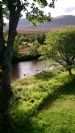
Dalwhinnie has changed over the years but has always been at the meeting point of the great road north and the great route west. Perhaps the earliest dwellings here were a cluster of drover's bothies, who knows? The A9 bypass has made the village quieter and safer but has had a knock-on effect on the local economy, as fewer people stop now.
 Map showing clachans The clachan or settlement of Pressmucherach and also Dallanach from an ancient map.Such clachans or ...
 Map showing "parish" of Dalwhinnie Old map showing the extent in yellow of the "parish" of Dalwhinnie-or the area served by the Mission...
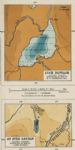 Loch Pattack bathymetric survey Loch Pattack bathymetric survey 1904.
 Loch Ericht bathymetrical survey Loch Ericht bathymetrical survey. The maximum depth found was 512 feet.
Not sure of date of survey...
Loch Ericht bathymetrical survey Loch Ericht bathymetrical survey. The maximum depth found was 512 feet.
Not sure of date of survey... Ancient historical sites around Dalwhinnie There are numerous ancient historical sites around Dalwhinnie - some will be obvious to many, others...
 Ancient map showing the "Clachans" Ancient map showing the "Clachans" which once existed in the area.eg."Presmucherach". There are more...
 Map of the Parish This 1892 map shows today's 'Fara' marked as Am Faireamh in Gaelic - perhaps anglicised to Varar Hil...
Latest Pics